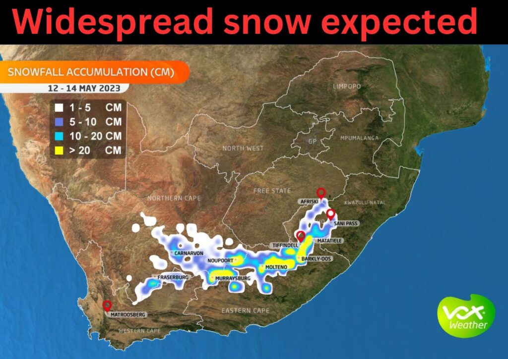
Widespread SNOW of up to 20cm is expected in these areas in South Africa this coming weekend. Here is the latest information.

By: Corné van Zyl
Widespread SNOW of up to 20cm is expected in these areas this coming weekend.
WIDESPREAD SNOW IS EXPECTED TO START ON SUNDAY
According to VoxWeather, widespread snow and a significant drop in temperatures are expected across the Cape Provinces from Friday to Sunday.
ALSO READ: WATCH: More SNOW expected TODAY in these parts of SA
Widespread snow of up to 20cm is expected to fall over the mountains of Murraysburg, Noupoort, Molteno, Tiffindell, Barkly-East, and Matatiele.
Snowfall of between 10- 20 cm is expected along the Sani Pass, Drakensberg Mountains, Carnavon, and Fraserburg.
Meanwhile, snow of between 5 – 10 cm is expected along Fraserburg mountain range, Carnarvon, Blaaukrantz, Klerkshoop, and Noupoort to Molteno.
PLEASE SEND US YOUR SNOW PHOTOS AND VIDEOS:
Please WhatsApp your photos and videos to 060 011 0211. Please remember to include your name, surname, and as many details and information as you have. You are, of course, welcome to send anonymous tips and information.
As usual, when snow falls in Lesotho, some of the high peaks in the surrounding areas, such as Underberg, Sanipass, Clarens, and the Swartberg, also get snow.
ALSO READ: Snow hunters – Here’s where to see snow in South Africa NOW
Last month, the first SNOW of the year was reported in several parts of the country.
See more weather on the live blog here: Weather live updates
LOOK AS THE FIRST SNOWFALL WAS CONFIRMED NOW
Here is where snow was reported:
- Southern Drakensberg area
- Bushmans Nek area near Underberg
- Ugie in the Eastern Cape
ALSO READ: What’s this now? ‘Thunder-snow’ in KZN confuses locals
The SA Weather Service (SAWS) has issued a yellow level 2 weather warning for severe thunderstorms in Gauteng for Monday afternoon, 8 May.
SEVERE THUNDERSTORMS AND POSSIBLE FLOODING IN GAUTENG
Currently, thunderstorms are moving over the West Rand region of Gauteng and slowly moving eastward, causing excessive lightning, heavy downpours, and the potential for strong winds and hail.
The impacts of these thunderstorms include:
- Localised flooding of low-lying roads and areas
- Localised power surges due to excessive lightning
- Poor driving conditions due to heavy rainfall and small hail
- Isolated incidents of trees being uprooted due to strong winds


