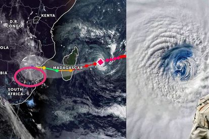
Tropical Cyclone Freddy made landfall along the eastern coastline of Madagascar, just north of Mananjary, around 19:30 SAST on Tuesday early evening, 21 February.
By: Michelle Swart
ALSO READ: Will Cyclone Freddy affect South Africa?
Cyclone Freddy makes landfall in Madagascar
The storm, which had winds of 150 km/h and gusts up to 180km/h, was a low-end category 2 tropical cyclone before making landfall.
The rugged terrain significantly weakened Freddy, and it was downgraded to an overland depression during the evening.
ALSO READ: Cyclone recovery expected to cost New Zealand billions
The World Meteorological Organization (WMO) designated Regional Specialized Meteorological Centre (RSMC) located at La Reunion forecasts that “Freddy” will continue in a west-south-westerly direction over the next few days, regaining its strength this evening as it moves into the Mozambique Channel.
Freddy may reach near-tropical cyclone status by Thursday evening while heading to southern Mozambique, making landfall just north of Vilanculos during Friday morning.
ALSO READ: Cyclone Freddy to move into Mozambique this coming week
System expected to affect South Africa
Over the next few days, “Freddy” is expected to affect the north-eastern parts of South Africa, especially the Lowveld and escarpment areas of Limpopo and Mpumalanga.
The weather system will be semi-stationary along the north-eastern border for a few days, and very heavy rainfall in the order of 200 to 400 mm is possible, resulting in widespread significant flooding.
The districts in question are Vhembe and Mopani in Limpopo, and to a slightly lesser extent, Ehlanzeni in Mpumalanga.
ALSO READ: Cyclone Freddy expected in Southern African countries
Recent significant flooding in the Lowveld and escarpment areas, such as the Kruger National Park, may exacerbate the situation, causing prolonged and severe impacts.
Although not as much rain is expected over other places in the north-eastern parts, residents of Capricorn (Limpopo), as well as Umkhanyakude, Zululand, and Amajuba (KwaZulu-Natal), are urged to be extra vigilant.
From Friday evening, strong winds caused by Feeddy are also expected in the north-eastern parts, with average speeds of about 45 km/h.
SAWS, in consultation with National and Provincial Disaster Management structures, will continue to monitor developments on a 24/7 basis and issue regular updates across a variety of media and social media platforms.
The SAWS said that the public can rest assured of this.


